Chambal Valley vs the Grand Canyon: One Wonder, One Wasteland

Fly over the Chambal at low altitude and the ground below looks broken. Thousands of gullies cut into pale earth, branching and rebranching until the land resembles a river system with the water taken out. Locals call it the beehad. It runs for roughly eight thousand square kilometres across Madhya Pradesh, Rajasthan and Uttar Pradesh.
Fly over the Grand Canyon and you see something structurally similar at a much larger scale: erosion, exposed strata, a river at the bottom that did the cutting.
One of them receives close to five million visitors a year and is on most lists of the natural wonders of the world. The other is officially classified, in Indian land-use records, as wasteland — and there have been repeated government proposals to level it.
Same process. Opposite verdict. The reason why turns out to be the most interesting thing about either place.
What each one actually is
The Grand Canyon is old rock, slowly removed. The Colorado River has been cutting downward for something like five to six million years, and the walls it has exposed run back roughly 1.8 billion years to the Vishnu Basement Rocks at the bottom. It is 446 kilometres long, up to 29 kilometres across, and about 1,857 metres deep at its deepest. It is a cross-section of geological time you can walk into.
The Chambal ravines are young soil, quickly removed. They are not carved into ancient bedrock but gullied out of soft alluvial deposits by monsoon runoff — a badlands system, geologically speaking, and one that is still actively growing. Where the Grand Canyon took millions of years, a Chambal ravine can deepen measurably within a human lifetime.
That distinction — bedrock versus soil, million-year versus decade-scale — is not just trivia. It is the whole reason the two landscapes ended up with opposite reputations.
The Wasteland Verdict
Here is the framework worth taking away. Call it the Wasteland Verdict.
Whether a landform is treated as a wonder or as a problem has almost nothing to do with how it looks, and almost everything to do with what it replaced.
The Grand Canyon consumed nothing anyone wanted. It cut through high desert plateau that was never farmed and could not have been. Nothing productive was lost to it, so it arrived in the modern era with no economic grievance attached, free to be admired. It became a national monument in 1908 and a national park in 1919.
The Chambal ravines ate farmland — and they are still eating it. Gully erosion in this basin converts cultivable alluvial soil into unfarmable, unroadable, un-irrigable terrain, and it advances. To the state, that is not scenery; it is land going out of production, hectare by hectare, in one of the most densely populated agricultural regions on earth. Hence the classification, and hence decades of "ravine reclamation" proposals: level the gullies, terrace the slopes, return the ground to cultivation.
So two nearly identical geomorphic processes get opposite verdicts, and neither verdict is really aesthetic. A landscape is called a wonder when it destroyed nothing and a wasteland when it destroyed something — and everything downstream follows from that first accounting.
What makes the Chambal genuinely instructive is that the verdict turned out to be wrong, and the evidence for that is swimming in the river.
Why the "wasteland" is the last clean river in north India
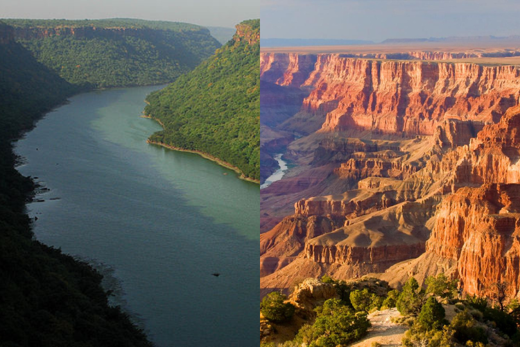
The Chambal is one of the least polluted rivers in India. In a region where almost every major river carries the effluent of dense settlement, industry and intensive agriculture, this one runs relatively clear, with deep channels, exposed sandbanks and stable riverside vegetation.
The reason is the ravines. Because the badlands were unfarmable and effectively unbuildable, no towns grew on the banks, no industry located there, and no irrigation channels drew the river down. The land nobody could use became, by accident, the largest protective buffer any river in northern India has.
What that buffer preserved is the National Chambal Sanctuary, established in 1979 and spanning all three states — a protected stretch of river running roughly 425 kilometres.
The headline species is the gharial, the narrow-snouted, fish-eating crocodilian that is one of the most endangered large animals on the planet. When conservation began on the Chambal in 1975, there were about 200 left here. In 2025 the count reached 2,026 in the Uttar Pradesh stretch of the sanctuary — the highest ever recorded, up from 1,880 the previous year, with around 1,186 hatchlings documented in a single season. The Chambal now holds the overwhelming majority of the world's surviving wild gharial.
It is not alone. The same water holds Ganges river dolphins, smooth-coated otters, mugger crocodiles, the critically endangered red-crowned roofed turtle, and one of the last strongholds of the Indian skimmer. All of it sitting inside terrain officially recorded as degraded.
The bandits were a land-use consequence
The Chambal's other reputation — the dacoit country of a hundred films — is usually told as a story about culture or lawlessness. It is more accurately a story about topography.
A ravine system is nearly impossible to police. There are no sightlines, no roads, thousands of dead ends and hiding places, and three state borders converging in the middle of it, which meant a pursuing force from one state hit a jurisdictional wall within an hour. Combine ungovernable terrain with a landscape nobody was economically invested in, and you get a refuge — for feuding families, for people escaping caste violence, and eventually for organised banditry that lasted well into the 1980s.
The dacoit era is over. What it left behind is the second layer of the Chambal's under-visiting: a place with a reputation for danger that has outlived the danger by four decades, in exactly the way the hitchhiking panic outlived the actual risk. Travellers still hesitate over a threat that was resolved before most of them were born.
What you actually do there
The Chambal is not a hiking destination, and treating it like one is the main way visitors are disappointed. The experience is on the water.
Boat safaris run from bases near Dholpur in Rajasthan, Bah and Agra in Uttar Pradesh, and Morena in Madhya Pradesh. A morning run puts you at eye level with gharial hauled out on sandbanks, muggers further along, dolphins surfacing in the deeper pools, and skimmers working the shallows. The birdlife is exceptional between November and March, when the migratory species arrive.
The best-known access point is the easiest to combine with something else: the sanctuary is roughly seventy kilometres from Agra, which means the Taj Mahal in the morning and a critically endangered crocodilian in the afternoon is an entirely reasonable day.
Season matters absolutely. Come between November and March. The monsoon transforms the river into something fast and turbid and closes the boats, and May and June in this part of India are punishing — the seasonal swing that governs travel across the whole subcontinent and follows directly from why India has a monsoon at all.
How the two places compare, honestly
If you want scale, the Grand Canyon wins and it is not close. Nothing in the Chambal approaches 1,857 metres of vertical exposure, and no photograph of a ravine system produces the effect of standing on the South Rim.
If you want infrastructure, the Grand Canyon wins again: shuttle buses, rim trails, lodges, rangers, a century of interpretive material. The Chambal has boats, a handful of small lodges, and forest department staff.
What the Chambal has that the Grand Canyon does not is wildlife density and solitude at the same time. The Colorado through the canyon is a heavily managed, dam-regulated river with a much-reduced native fish fauna. The Chambal is a functioning riverine ecosystem holding several species that exist almost nowhere else, and you will often be the only boat on it.
Which is the more interesting place depends entirely on what you came for. Geology and grandeur: Arizona. A living river and the sense of arriving somewhere before the crowd: Chambal. It belongs in the same category as the other under-travelled corners of India that reward the effort of reaching them, and in a different one entirely from the country's big mountain objectives.
The argument that is coming
The Wasteland Verdict has not gone away, and it is now the central conflict over this landscape.
Ravine reclamation remains on the policy table across all three states: level the badlands, restore the land to agriculture, add several thousand square kilometres of cultivable ground in a region that badly wants it. As a development case it is coherent, and the pressure behind it is not frivolous.
Set against it is everything the ravines have been quietly protecting. There has also been recurring pressure to denotify or shrink parts of the sanctuary, alongside persistent illegal sand mining, which removes the exact sandbanks gharials need for nesting and basking.
The choice is real, and it is not resolved. But the gharial numbers are the clearest available evidence about what happened when a landscape was left alone because nobody could think of a use for it: 200 animals in 1975, more than 2,000 in 2025, in the one river in northern India that industry never reached.
That is worth remembering the next time a piece of ground is filed as worthless. The category is a description of our plans for it, not of what it is doing.
Sources
- National Chambal Sanctuary — extent, species and protection status
- The Better India — Chambal Sanctuary records highest gharial count with 2,026 in 2025
- Wildlife Trust of India — Saving gharials, one egg at a time
- US National Park Service — Grand Canyon geology and formation
- Drishti IAS — National Chambal Sanctuary: ecology, threats and policy